The Neighborhood
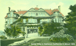
Arbor Villa / Ivy Hill Neighborhood:
The Ivy Hill neighborhood runs roughly from Park Blvd. to 8th Avenue. As with the rest of the 17Y area, its housing stock also ranges from the late 1800s to the 1960s, but in addition several large vintage apartment buildings have been preserved, particularly along Ivy Street for which the neighborhood is named. These display architectural details no longer found in buildings of more recent vintage.
The palm trees that line Ninth Avenue once formed the border of entrepreneur Francis Marion “Borax” Smith’s 1890s estate Arbor Villa. The grounds of Arbor Villa covered 50 acres and contained an observation tower for what must have been stunning views from the top of Ivy Hill. The villa had 42 rooms including 15 bedrooms, a bowling alley, and a miniature Borax mine.
www.city-data.com/neighborhood/Ivy-Hill-Oakland-CA.html
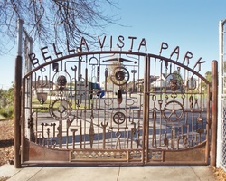
Bella Vista Neighborhood:
The Bella Vista neighborhood is one of Oakland’s oldest neighborhoods, and its history and interesting mix of housing styles and sizes give it some of its most colorful character. It is located in the heart of Beat 17Y, nestled roughly between East 33rd Street, 13th Avenue, East 24th Street and Ninth Avenue.
There’s an intriguing assortment of home sizes within the neighborhood, from small bungalows to grand estates. Architectural styles vary as well; traditional Craftsman homes lining one block, Mediterranean-style houses commanding the next, and Victorian “painted ladies” just around the corner. This interesting mix carries over into the ethnic character of the neighborhood; not one specific ethnic group dominates the area.
The palm trees that line Ninth Avenue once formed the border of entrepreneur Francis Marion “Borax” Smith’s 1890s estate (see above) in the Arbor Villa / Ivy Hill neighborhood.
http://www.city-data.com/neighborhood/Bella-Vista-Oakland-CA.html
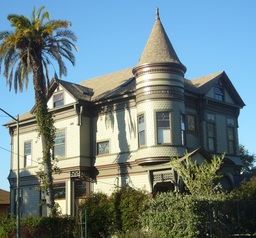
Clinton / 10th Avenue Historic District / Artist Live-Work Spaces
The Brooklyn Neighborhood Preservation Association, an active neighborhood group in the 1980’s and 90’s is responsible for many preservation efforts in the larger neighborhood, including the designation of the “10th Avenue Historic District” in 1988, Oakland’s first historic district.
The district encompasses homes from 1930 10th Avenue to 2136 10th Avenue. Among this cluster of fine “specimen” houses are 2100 10th Ave (1891, John J. & Thomas D. Newsom, architects), 2020 10th Avenue (1912, Julia Morgan, architect) and 2004 10th Avenue (1907, Albert Farr, architect).
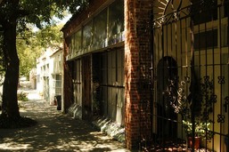
At the other end of the Clinton neighborhood on E. 24th Street and 8th Avenue is a row of artist live-work studios. This stretch of commercial storefronts - three separate buildings - were built around 1930. Dixi and Mario Carrillo bought 816/820 E. 24th Street in 1975. Subsequently they bought the five corner storefronts in 1979 and the third building at 812 E. 24th Street in 1984.
In 1931 a Piggly Wiggly market anchored the corner building. It later became a Safeway store. In 1931 there were also a bakery, cleaners and a candy store. Over the years other businesses included a beauty shop, restaurant, real estate office, launderette, liquor store, radio store, TV repair store, record store. Artist Nathan Oliveira’s parents ran the Reliable Cleaners, and he grew up in a house on 8th Avenue. When Dixi and Mario bought 816 it was mostly vacant with some carpet storage. 820 was originally a beauty parlor, but when they bought it, it had become the B-29 Club, popular during WWII to residents in the apartment buildings on 8th Avenue. Only the Cut Rate SuperMarket was still in business when they bought the corner building. 812 E. 24th Street, which had been the launderette, was also vacant when they bought that building.
In 1931 a Piggly Wiggly market anchored the corner building. It later became a Safeway store. In 1931 there were also a bakery, cleaners and a candy store. Over the years other businesses included a beauty shop, restaurant, real estate office, launderette, liquor store, radio store, TV repair store, record store. Artist Nathan Oliveira’s parents ran the Reliable Cleaners, and he grew up in a house on 8th Avenue. When Dixi and Mario bought 816 it was mostly vacant with some carpet storage. 820 was originally a beauty parlor, but when they bought it, it had become the B-29 Club, popular during WWII to residents in the apartment buildings on 8th Avenue. Only the Cut Rate SuperMarket was still in business when they bought the corner building. 812 E. 24th Street, which had been the launderette, was also vacant when they bought that building.
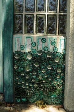
Mario and Dixi moved in to 816 E. 24th Street, and through the years converted all of the other storefronts to art studios, ranging from 750 SF to 2000 SF. Many of the artists have occupied their spaces for an extended period of time: two of them for more than 20 years.
Artists have included painters, sculptors, ceramicists, musicians, stained glass artists, photographers, woodworkers, graphic designers, video artists, a muralist, weaver, print maker and jeweler.
Mario, primarily a painter, did the gates and all of the ceramic tile work on the facades of five of the units.
Highland Park (Lynn)
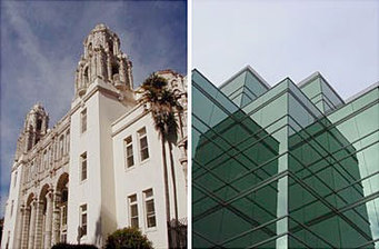
Highland Park is the area immediately surrounding and dominated by Highland Hospital, loosely bounded by 14th Avenue on the east, E. 33rd Street to the north, E. 24th Street to the south, and 13th Avenue to the west.
Lynn was an early settlement, located northeast of Brooklyn. In 1870, Lynn and Brooklyn incorporated as Brooklyn. In 1872, voters approved the annexation by Oakland.
Lynn hosted a large shoe and boot factory, and was named after Lynn, Massachusetts which also had a large footwear industry.
Highland Hospital is undergoing a major renovation/expansion at the moment (2011-2014). Its trauma center is recognized as one of the premier facilities in the United States serving accident and violence victims throughout the Bay Area. Its Emergency Department offers outstanding trauma training for physicians and other health care professionals.
www.city-data.com/neighborhood/Highland-Park-Oakland-CA.html
History of the larger San Antonio District
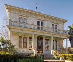
The neighborhood is part of the historic San Antonio district encompassing the land east of Lake Merritt to Sausal Creek. It takes its name from Rancho San Antonio, the name of the land as granted to Luís María Peralta by the last Spanish governor of California (pictured: Peralta Hacienda, on Sausal Creek).
The settlement that became San Antonio began in 1851 when J.B. Larue purchased Peralta's land west of San Antonio Creek. The site was west of Clinton. Larue built a store and wharf and the community grew up around them. The San Francisco and Oakland Railroad built a station at San Antonio. When the Central Pacific Railroad took over the line in 1870, the name was changed to Brooklyn. When the Southern Pacific Railroad took over the line in 1883, the name was changed to East Oakland.
Clinton and San Antonio joined in 1856 to form a new town called Brooklyn named after the ship that had brought Mormon settlers to California in 1846. Brooklyn joined with nearby Lynn to incorporate in 1870 under the name Brooklyn. In 1872, Brooklyn voters approved their city's annexation by Oakland.
More info on San Antonio: http://www.sanantoniooakland.org/history/index.htm
